Blackwater Death Site: Where were Morton, Baker, and McCloskey killed?
Part 1: Buckwater Springs
While researching the location of the 1878 murders of Buck Morton, Frank Baker, and William McCloskey, I made a discovery that could change the face of the US map.
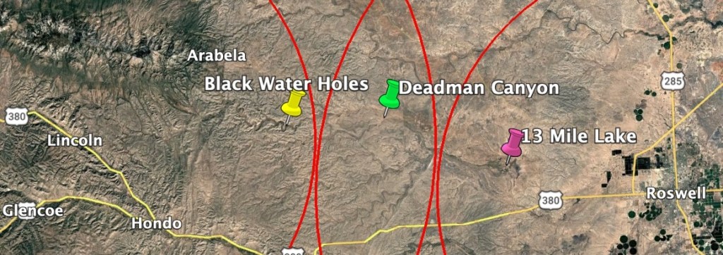
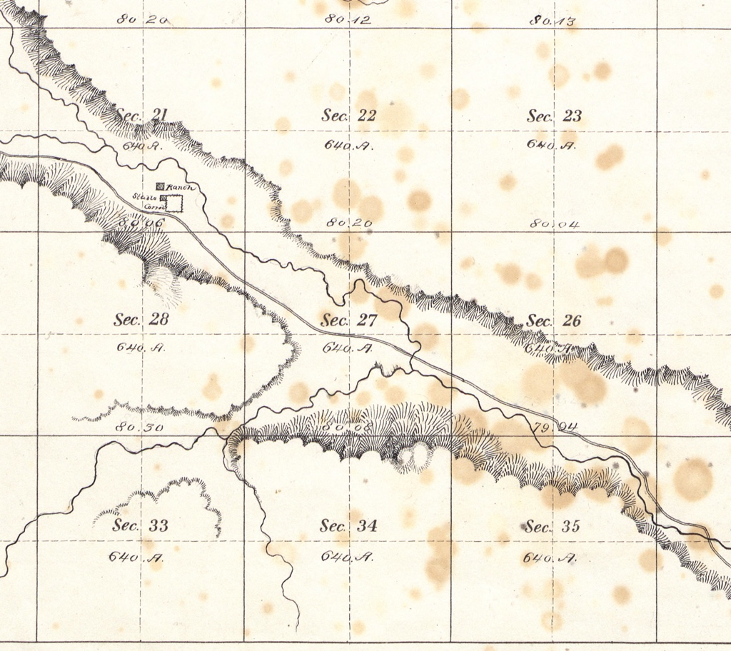
The literature has long pointed to an old road that ran up Blackwater Canyon as the scene of the killings. Blackwater Canyon, Blackwater Draw, Blackwater Springs, Black Water Holes, Agua Negra- are all names attributed to the features of the neighborhood where the assassinations took place. It’s common for geographic features of the same locality to share the same name. Creeks are often named after their source spring and canyons for the waters they carry. This can be confusing when trying to identify the death site, as the Blackwater covers a large swath of land. Sources sometimes reference the springs as an anchor point, so it was important to find them.
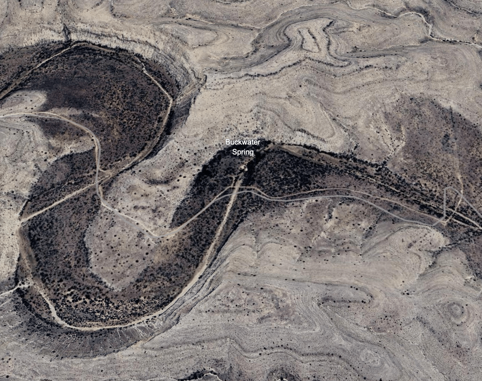
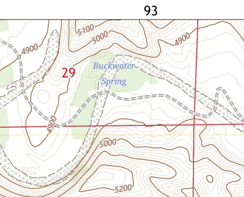
Finding Blackwater Canyon on a map was easy. And since the creek runs down the canyon, finding the one, revealed the other. But scrolling up and down Blackwater Canyon on Google Earth, failed to uncover any sign of Blackwater Springs. Plugging the name and its many variants into the search box harvested no results. I tried other GPS and mapping applications with no luck. The most likely looking spot was a snaking pool of water and dark vegetation near the top of the canyon called “Buckwater Springs.” Close but no cigar.
Next, I searched for “Blackwater Springs” in the GNIS.
The Geographic Names Information System (GNIS) was established in the 1970s by the USGS as the first digital repository of official names for every documented geographic feature in the United States. The idea was to ensure consistent designations across multiple platforms. Federal, state, and private cartographers would be able to access the GNIS to retrieve accurate, standardized, and up to date place names for the maps they produced for customers and or citizens.
There was no record for “Blackwater Springs” in the GNIS.
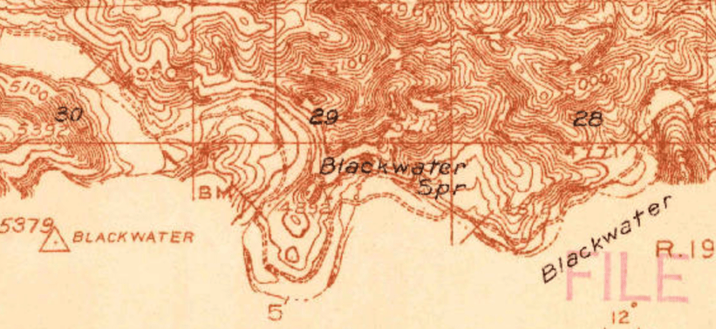
But then I found it. Not in the GNIS, but on a 1927 USGS survey which clearly labeled Blackwater Springs. And lo and behold, it was Buckwater Springs. Buckwater and Blackwater were one and the same. A name change? When? Why?
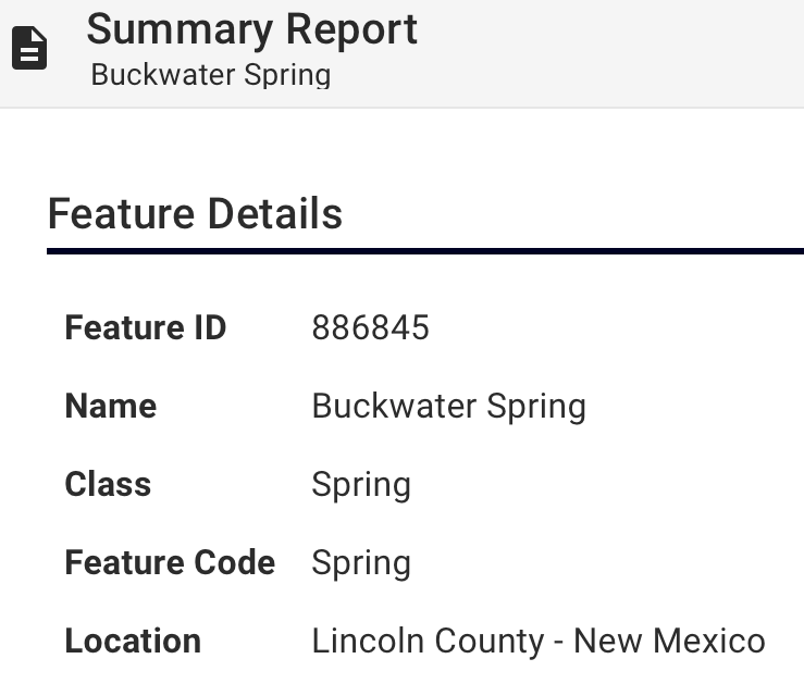
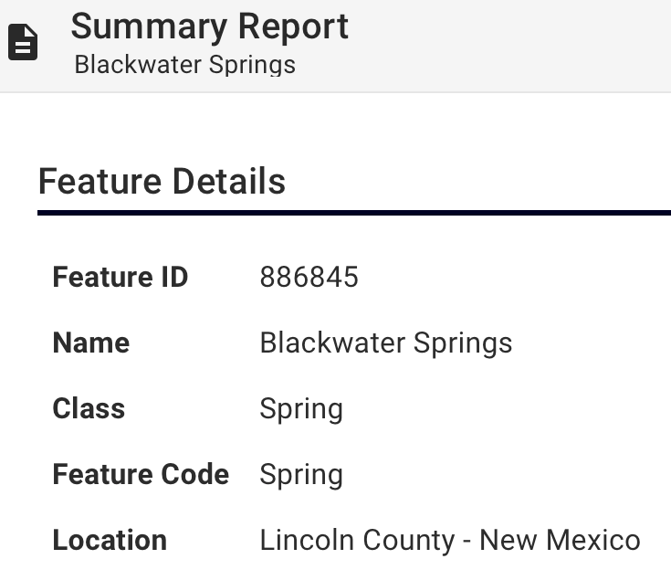
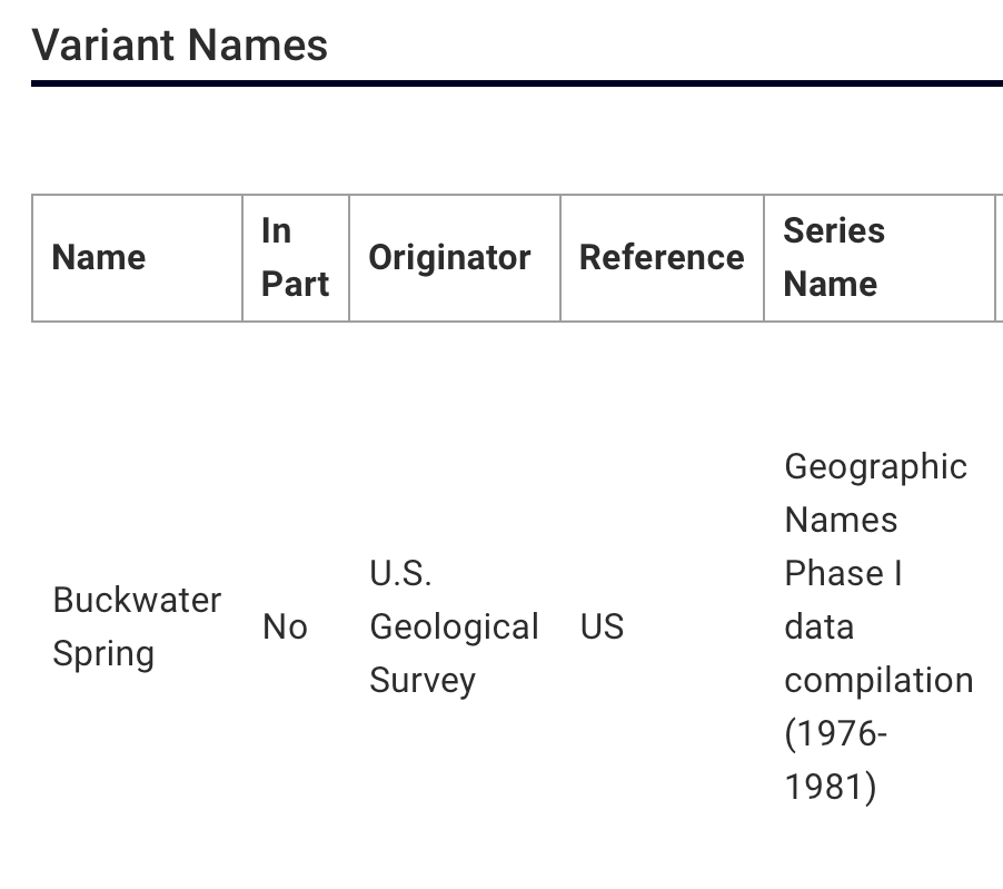
I went back to the GNIS and searched for “Buckwater.” It was there. Feature ID 886845 was entered into the system November 13, 1980. The coordinates matched Blackwater Springs exactly.
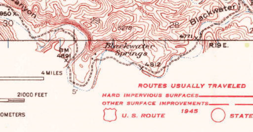
Going back to the 1927 USGS survey, where the spring was still called “Blackwater,” I worked my way forward in time. The “Blackwater” designation continued to be used for this feature on USGS maps in 1936, 1942, and as late as 1971. After that… poof. It entered the GNIS database under the name “Buckwater.”
The significance of the name “Buckwater” in the context of Buck Morton’s death, had to be acknowledged. Were the springs renamed in his honor? Or was this just a synchronistic typo?
If the springs had been officially renamed, it would have happened sometime in the 1970s before its entry into the dataset in 1980. If that were the case, there would have been an alternate name recorded in the file for Feature ID 886845. There was not. And after what happened next, it was clear there was never an official name change. This was a typo.
Phase I of the implementation of the GNIS, took place between 1976 and 1981, and, again, involved manually transferring hundreds of thousands of geographic feature designations from every US state and territory into a single database for the first time. Unsurprisingly, there were errors.
I reached out to the USGS and found out that official name changes were very rare. When it did happen, it usually involved removing offensive language and not so much to honor individuals. Although it does happen, there was nothing to it in this case. This was a typo. There was, however, a protocol for correcting potential mistakes in the database. The onus was on me to submit proof of the error. Strange as it sounds, I emailed the USGS their own USGS maps from 1936, 1942, and 1971. They were accepted. The error was corrected.
In October of 2024, Buckwater Springs (Feature ID 886845) had its name officially changed in the GNIS back to “Blackwater Springs,” as it should have been entered in 1980, to accurately portray the historic geographic record. And while the locals in Lincoln County might know where Blackwater Springs are without looking at a map, I am not a local. The rest of us depend on this stuff.
While the GNIS has been updated to the name “Blackwater,” third party applications may not reflect the change for some time to come. The USGS suggested 2026 at the earliest. And while I’m thrilled with the GNIS name correction, only when I see it on Google Earth, will I feel like the work is done.
Part of me wanted to leave it named for Buck Morton. A coincidental honor is still an honor. But he’s already had his name on it for over 40 years, and no name is ever deleted from the GNIS. “Buckwater” will forever be a part of Feature ID 886845, as it will remain in the file as a variant name. So, Buck lives on.
Part 2: Deadman Canyon
With the springs’ location confirmed, in relation to the canyon, the creek, Roswell, and Lincoln, it was time to reexamine the eyewitness testimony. Superimposing the accounts of those present at the killings, onto the landscape helped narrow down the potential vicinity of the killings.
First testimony in 1878:
“When we had ridden some 20 miles [from Roswell], and had reached a point some 5 or 6 miles from Black Water…” – Frank McNab via Ash Upson’s March 10, 1878 letter to the Mesilla Valley Independent
“… when within 30 miles of Lincoln…” – Richard Brewer via Alexander McSween, Angel Report Witness Statement, June 6, 1878
“When within 25 miles of the town of Lincoln…” – John Middleton, Angel Report Witness Statement, June 13, 1878
“… near Black Water.” – Henry Brown, Angel Report Witness Statement, June 13, 1878
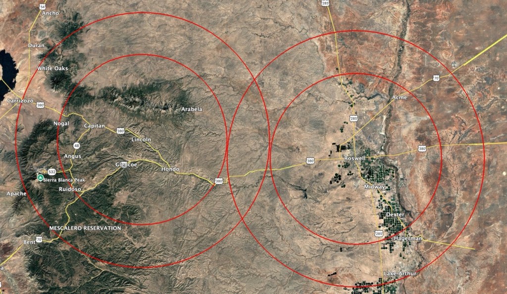
Drawing two concentric circles- one at a 20 mile radius (as the crow flies) and one at a 30 mile radius- around both Lincoln and Roswell, creates a Venn diagram across the landscape. Where the circles intersect, is the area that best fits the 1878 descriptions of the murder site.
In the years that followed, more descriptions were given by others apparently in the know. These reinforced the 1878 testimony and included additional details that may narrow down the location of the murders:
“About 20 or 30 miles from Roswell, near the Black Water Holes…” – Pat Garrett, Authentic Life of Billy the Kid, 1882
“… halfway between 13 Mile Lake and Blackwater in a pretty little valley.” – John Meadows, Pat Garrett and Billy the Kid as I Knew Them, 1931
“About 25 or 30 miles from Roswell, near Agua Negra Spring…” – Miguel Otero, The Real Billy the Kid, 1936
“… a place about 5 miles below Agua Negra spring… in what was thereafter to be known as Dead Man’s Draw.” – Maurice Fulton and Robert Mullin, History of the Lincoln County War, 1968
“… in what is now called Dead Man’s Canyon…” – Frederick Nolan, Garrett’s Authentic Life of Billy the Kid Annotated Edition, 2000
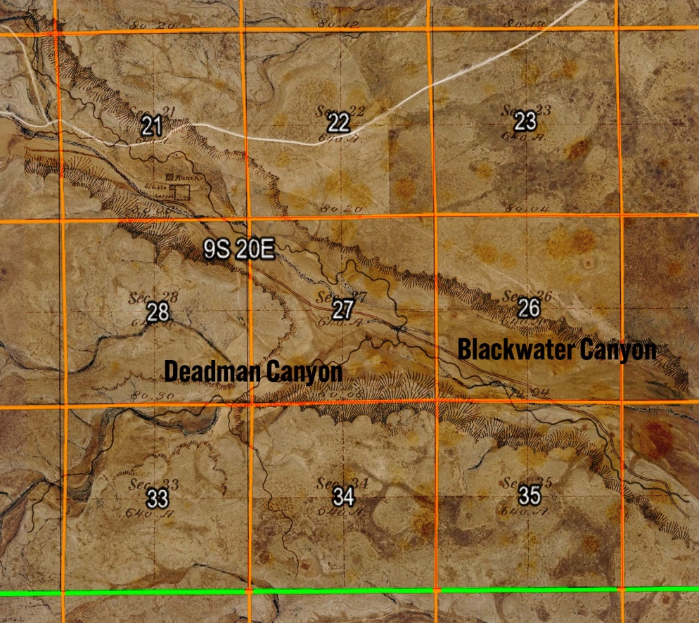
These statements fit well with the 1878 testimony Venn diagram. Notably, Deadman Canyon is named as the locale, which is smack dab in the middle the intersecting red circles.
Deadman Canyon met all the criteria.
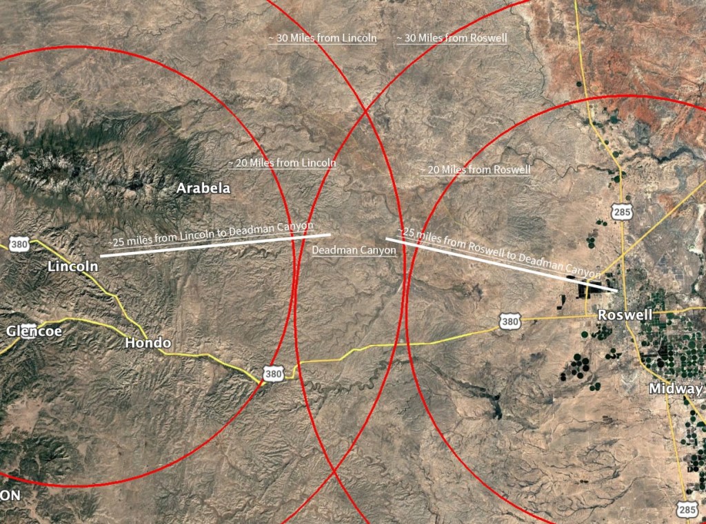
Hard to ignore the sum of evidence pointing directly at this area as the scene of the shooting (and perhaps even the burial) of Morton, Baker, and McCloskey. The intersection of Blackwater and Deadman Canyons is the most plausible location for the death site.
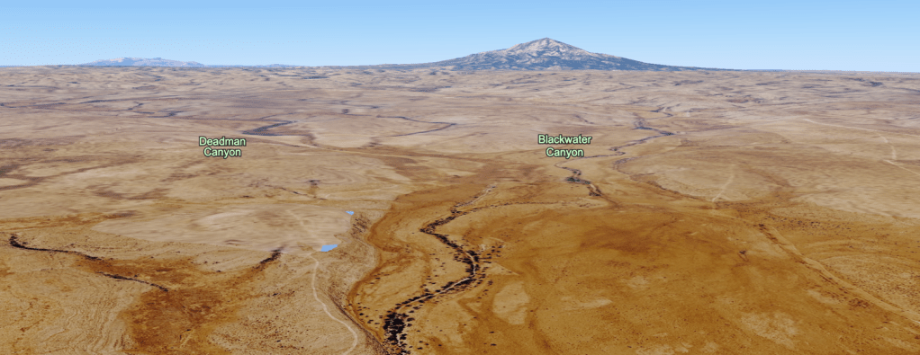
Google Earth shows where Deadman Canyon intersects Blackwater Canyon.
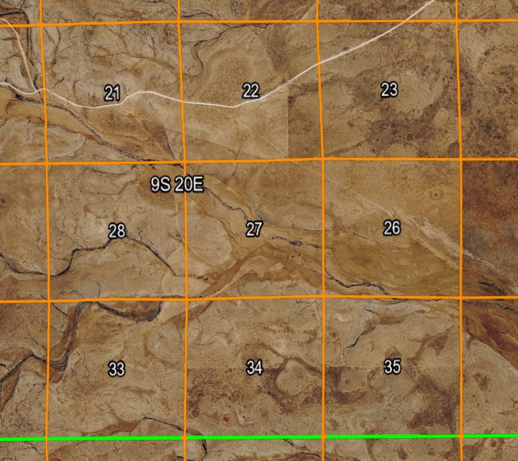
A March 1882 survey shows the area four years after the murders.
Here is a composite of the two.
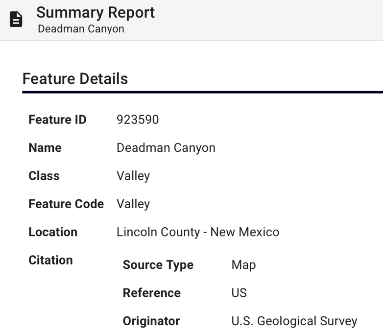
And while “Buckwater” was a synchronistic typo, there’s little doubt that Deadman Canyon was named after one or all of the Regulators’ victims. It wears that designation indefinitely, as it was entered into the GNIS as Feature ID 923590.
Part 3: Pretty Little Valley
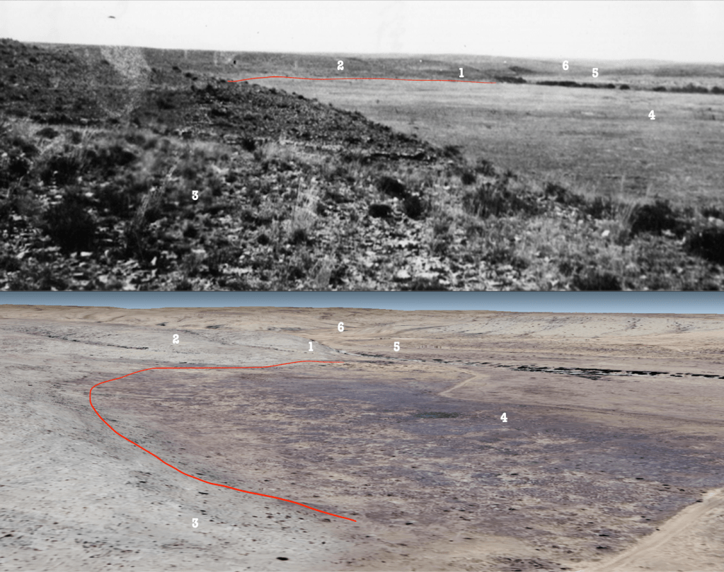
In July of 2025, BTKHC released an image of a photograph they found in an undisclosed collection in Roswell. It was suggested that it was taken around the springs. Having spent quite a bit of time with satellite imagery of the area, I recognized it as John Meadows’ “pretty little valley.” Using Google Earth, I found the approximate viewpoint from where the picture was taken. It was in Blackwater Canyon, less than a mile from the mouth of Deadman Canyon. I sent the location to the Coalition. They seemed to agree. They sent me several other photos from the same collection that I was also able to ID. This generated some excitement. My impression is that they hope to visit the site someday. But they’re keeping it very hush hush for the time being.
- Colin Asquith, February 18, 2026
